المدة الزمنية 2:23
MAP OF UAE [ UNITED ARAB EMIRATES ]
تم نشره في 2023/03/02
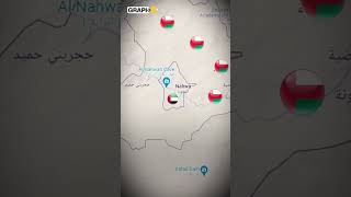
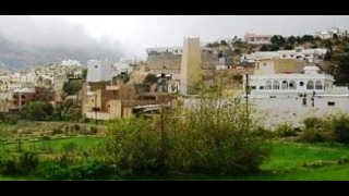
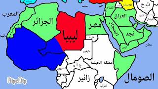
hello my friends. this is a map of the United Arab Emirates. The UAE coast stretches for nearly 650 km along the southern shore of the Persian Gulf, briefly interrupted by an isolated outcrop of the Sultanate of Oman. Six of the emirates are situated along the Persian Gulf, and the seventh, Fujairah is on the eastern coast of the peninsula with direct access to the Gulf of Oman. Most of the coast consists of salt pans that extend 8–10 km inland. The largest natural harbor is at Dubai, although other ports have been dredged at Abu Dhabi, Sharjah, and elsewhere. Numerous islands are found in the Persian Gulf, and the ownership of some of them has been the subject of international disputes with both Iran and Qatar. The smaller islands, as well as many coral reefs and shifting sandbars, are a menace to navigation. Strong tides and occasional windstorms further complicate ship movements near the shore. The UAE also has a stretch of the Al Bāţinah coast of the Gulf of Oman. The Musandam Peninsula, the very tip of Arabia by the Strait of Hormuz, and Madha are exclaves of Oman separated by the UAE. Roads leading to Jebel Jais, the highest mountain in the UAE, in Ras Al Khaimah. South and west of Abu Dhabi, vast, rolling sand dunes merge into the Rub al-Khali (Empty Quarter) of Saudi Arabia. The desert area of Abu Dhabi includes two important oases with adequate underground water for permanent settlements and cultivation. The extensive Liwa Oasis is in the south near the undefined border with Saudi Arabia. About 100 km to the northeast of Liwa is the Al-Buraimi oasis, which extends on both sides of the Abu Dhabi-Oman border. Lake Zakher in Al Ain is a human-made lake near the border with Oman. thats all. please comment and subscribe for the best maps. goodbye. أهلا أصدقائي. هذه خريطة لدولة الإمارات العربية المتحدة. يمتد ساحل الإمارات العربية المتحدة لما يقرب من 650 كم على طول الشاطئ الجنوبي للخليج العربي ، وتقطعه لفترة وجيزة نتوء معزول لسلطنة عمان. تقع ست إمارات على طول الخليج العربي ، والسابعة تقع على الساحل الشرقي لشبه الجزيرة مع منفذ مباشر إلى خليج عمان. يتكون معظم الساحل من أحواض الملح التي تمتد من 8 إلى 10 كيلومترات في الداخل. يقع أكبر ميناء طبيعي في دبي ، على الرغم من تجريف الموانئ الأخرى في أبو ظبي والشارقة وأماكن أخرى. توجد العديد من الجزر في الخليج الفارسي ، وكانت ملكية بعضها محل نزاعات دولية مع كل من إيران وقطر. تشكل الجزر الأصغر ، بالإضافة إلى العديد من الشعاب المرجانية والحواجز الرملية المتحركة ، تهديدًا للملاحة. تزيد المد والجزر القوية والعواصف الهوائية العرضية من تعقيد تحركات السفن بالقرب من الشاطئ. تمتلك دولة الإمارات العربية المتحدة أيضًا امتدادًا لساحل الباطنة على خليج عمان. شبه جزيرة مسندم ، الطرف ذاته من شبه الجزيرة العربية بجانب مضيق هرمز ، والمدحاء هي جزائر عُمان تفصلها الإمارات العربية المتحدة. الطرق المؤدية إلى جبل جيس ، أعلى جبل في الإمارات ، في رأس الخيمة. جنوب وغرب أبو ظبي ، تندمج الكثبان الرملية الشاسعة المتدحرجة في الربع الخالي (الربع الخالي) في المملكة العربية السعودية. تضم المنطقة الصحراوية في أبو ظبي واحتين مهمتين بهما مياه جوفية مناسبة للاستيطان الدائم والزراعة. تقع واحة ليوا الواسعة في الجنوب بالقرب من الحدود غير المحددة مع المملكة العربية السعودية. تقع واحة البريمي على بعد حوالي 100 كيلومتر إلى الشمال الشرقي من ليوا ، والتي تمتد على جانبي الحدود بين أبوظبي وعمان. بحيرة زاخر في العين هي بحيرة من صنع الإنسان بالقرب من الحدود مع عمان. هذا كل شئ. الرجاء التعليق والاشتراك للحصول على أفضل الخرائط. مع السلامة. Hola mis amigos. Este es un mapa de los Emiratos Árabes Unidos. La costa de los Emiratos Árabes Unidos se extiende por casi 650 km a lo largo de la costa sur del Golfo Pérsico, interrumpida brevemente por un afloramiento aislado del Sultanato de Omán. Seis de los emiratos están situados a lo largo del Golfo Pérsico, y el séptimo, Fujairah, está en la costa este de la península con acceso directo al Golfo de Omán. La mayor parte de la costa consiste en salinas que se extienden de 8 a 10 km tierra adentro. El puerto natural más grande está en Dubai, aunque se han dragado otros puertos en Abu Dhabi, Sharjah y otros lugares. Numerosas islas se encuentran en el Golfo Pérsico, y la propiedad de algunas de ellas ha sido objeto de disputas internacionales tanto con Irán como con Qatar. Las islas más pequeñas, así como muchos arrecifes de coral y bancos de arena móviles, son una amenaza para la navegación. Las fuertes mareas y las tormentas de viento ocasionales complican aún más los movimientos de los barcos cerca de la costa. Los EAU también tienen un tramo de la costa de Al Bāţinah del Golfo de Omán. La Península de Musandam, la punta misma de Arabia por el Estrecho de Ormuz, y Madha son enclaves de Omán separados por los Emiratos Árabes Unidos. Carreteras que conducen a Jebel Jais, la montaña más alta de los Emiratos Árabes Unidos, en Ras Al Khaimah. Al sur y al oeste de Abu Dhabi, vastas y ondulantes dunas de arena #uae #uaenews #uaelife #unitedarabemirates #unitedarabemirate #mapschool #mapsolo #petamap #cartemap #kartemap #mapamap /watch/0zpL-FzLnYSLL
الفئة
عرض المزيد


تعليقات - 0
مقاطع الفيديو ذات الصلة على MAP OF UAE [ UNITED ARAB EMIRATES ]: